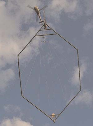
NEW DELHI (TIP): Water scarcity is endemic in our country. With groundwater irrigation accounting for over 60% of the total area irrigated, it’s important to save this precious resource. Recognising this, the ministry of water resources has, for the first time, started a Rs 41cr pilot project to map aquifers. Expected to be completed by May 2014, it will use specialized choppers to find clean, drinking water. The mapping began recently in Dausa near Jaipur and will cover five more areas. This pilot project is part of a mega one — the National Project on Aquifer Management — to map aquifers all over India and will cover 21 million sq km. It has been taken up during the 12th and 13th Five Year Plans. The project is in conjunction with the Central Ground Water Board and National Geophysical Research Institute (NGRI), Hyderabad, and is funded by World Bank. While the country has enough water, its distribution is uneven, said an official of the ministry of water resources.
“In order to assess ground water, we need a three-dimensional geometry of aquifers so that we know how much to extract. Eventually, the community and state governments will manage these,” he said. Aquifers, incidentally, are ground water deposits and can be found at a depth of 200-500m. The six areas covered under the pilot project have been selected on the basis of soil types and topography. Dausa, for example, has hard rock with alluvium. “The others places include Chandrabhaga in Nagpur (Deccan basaltic traps), Tumkur in Karnataka (granite), Cuddalore in Tamil Nadu (coastal area), Ramgadh in Jaisalmer (desert environment) and Patna (alluvial soil),” said Shakeel Ahmed, chief scientist at NGRI. The matrix that evolves from this pilot project will be used in the rest of the country. For the first time, aerial geophysical techniques are being used to cover a wide area and even inaccessible ones.
Using a Danish technology called Skytem, a specialized Eurochopper is hooked below with a 30-m long probe which has a huge frame of 300 square metres. The chopper flies low — 3,500km high — and slowly at a speed of 60-80km per hour so that the frame doesn’t swing too much, said Ahmed. “Through the loop, which is made of fibre optics, electromagnetic currents are sent to the ground and the magnetic field thus generated is measured. This allows us to see the distribution of water, how much there is and at what depth,” says Ahmed. “It’s important to have a chopper which can carry half-a-ton weight under it. It’s especially useful in dry and coastal areas.” This technique, incidentally, has been used to map half of Denmark, informs Lars Jensen, senior field manager, SkyTEM, from Jaipur. “We have also used it in Australia, Malaysia, Antarctica, South Africa and America. We will finish mapping Jaipur within two weeks and cover an area of some 600 square kilometres,” he said.


Be the first to comment