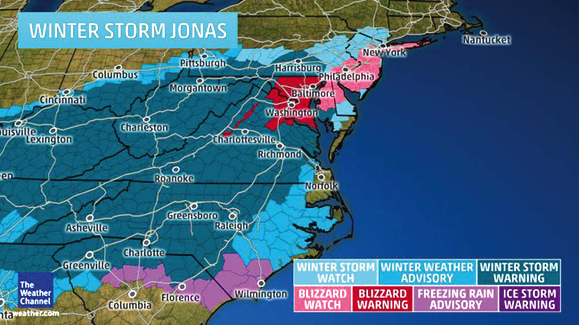
NEW YORK (TIP): The monstrous winter storm is coming to disrupt life, starting Friday, January 22. After an initial round of snow and ice, Storm Jonas will turn into a major snowstorm for the East Coast with strong, possibly damaging winds, significant icing and coastal flooding.
Heavy snow is expected to fall across parts of at least 15 states, with blizzard conditions possible over parts of the Washington D.C., Baltimore and New York City metro areas.
More than 50 million people could be affected by the “potentially paralyzing storm” headed for the East Coast this weekend, according to National Weather Service Director Louis Uccellini said on a call with reporters Thursday afternoon. CNN put the figure at 75 million.
The New York area will face the storm early Saturday for its first winter storm of the season and could see up to 8 inches of snow by Saturday night. Temperatures in the city are forecast to drop into the high 20s to the low 30s, according to the National Weather Service.
New York City Mayor Bill de Blasio said during a news conference on Thursday, Jan 21, that anyone in the area who planned to take “big trips over the weekend, get that out of your mind” and urged motorists to stay off the road.
CNN predicts it will be “one nasty snowstorm” that could leave the cities covered in a couple of feet of snow. The storm will start in the south and the Ohio Valley on Friday before moving north on Friday night and into Saturday morning, AccuWeather reported. By Sunday night, it will be over.
The storm could shut down highways and airports, according to AccuWeather. “This could be a long-duration snowfall that could last more than 24 hours in some locations,” AccuWeather meteorologist Elliot Abrams said.
Howling winds and pounding surf along the coasts could cause “substantial” beach erosion and coastal flooding, as well as property damage, the National Weather Service said.
Parts of Missouri, Kentucky, West Virginia, Virginia and North Carolina can expect ice accumulations that will mean slick roads, tree damage and power outages, AccuWeather said.
Snow and Ice Impacts
- At least 6 inches of snow likely: I-95 corridor northward through New York City/Long Island, westward into the Ohio Valley and northwest Tennessee.
- At least 1 foot of snow likely: Eastern Kentucky into most of West Virginia, Virginia except southeast portion, most of Maryland, D.C., northern Delaware, far southern Pennsylvania and extreme northwest North Carolina. Parts of these areas may see more than 20 inches of total snowfall.
- Sharp snowfall gradient: There remains considerable uncertainty regarding snow amounts on the northern edge of Jonas’ snow shield from Pennsylvania to southern New England. These areas could see snowfall exceeding 6 inches, but confidence is not as high as areas just to the south.
- Ice: The highest probability of accumulating ice to the extent of not only leading to slick roads, but also some tree damage and power outages is also possible.
High Winds
- Strongest wind potential: Delmarva Peninsula, Chesapeake Bay, New Jersey and Long Island Saturday. Occasional gusts to 60 mph, coupled with the weight of wet, heavy snow in some of these areas, will likely lead to power outages, downed trees and limbs, and perhaps some structural damage.
- Additional strong gusts: Washington and Baltimore metropolitan areas, where blizzard conditions are possible; New England coast, particularly southeast New England, Cape Cod, Nantucket Island and Martha’s Vineyard; North Carolina’s Outer Banks. There will also be rather strong winds gusts in the Mid-South region of west Tennessee, southeast Missouri, eastern Arkansas and northwest Mississippi Friday that could also produce local blizzard conditions in spots. The combination of heavy snow and these strong winds could lead to power outages and some downed trees/limbs.
Predictably, meteorologist message boards & social media are abuzz with the storm’s potential. One leading meteorologist on Twitter has already dubbed the storm a “blockbuster blizzard for the ages.” The person who literally wrote the textbook on major Northeast winter storms, Paul Kocin, wrote on Tuesday, Jan 19, that this week’s storm is “textbook.” Another meteorologist called the storm’s predicted evolution “perfection.”


Be the first to comment