BENGALURU (TIP): Two days after the catastrophic floods due to cloudburst and intense rainfall in Dharali and Harsil villages in Uttarkashi district of Uttarakhand, Indian Space Research Organisation’s National Remote Sensing Centre (NRSC) shared analysis of the floods based on satellite data. Using high-resolution images of the Indian Cartosat-2S satellites, the teams drew a comparative analysis of the satellite images taken on August 7 (post the event) and cloud-free satellite images taken before the event on June 13, 2024, showing the extent and severity of the destruction. “The satellite images will help in the ongoing search and rescue operations to reach those stranded, and restore connectivity to the isolated region,” the ISRO report said, and cautioned that increasing events highlight the vulnerability of the Himalayan settlements to disasters. (ENS)
Breaking News
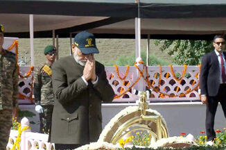
Kargil Victory Day : PM Modi pays homage to Kargil war martyrs in Drass
LADAKH (TIP): Prime Minister Narendra Modi, Indian Army Chief General Upendra Dwivedi, Chief of Air Staff Air Chief Marshal V.R. Chaudhari and Navy Chief Admiral Dinesh K. Tripathi paid tributes to soldiers at the Kargil […]

Frontpage News
No communication on H-1B visa cap received from US, says India
NEW YORK / NEW DELHI (TIP): According to a media report, the US is considering restrictions on H-1B visa that allow foreign professionals to work in that country. However, India has not received any communication […]

India
PM leaves for France, Slovakia and G7 Summit
New Delhi (TIP): Prime Minister Narendra Modi on Saturday departed on a six-day visit to France and Slovakia, during which he will hold talks with French President Emmanuel Macron, undertake the first-ever visit by an […]
Be the first to comment